In this interview, Emil Drápela, a geographer at the Technical University of Liberec, discusses how nineteenth- and early twentieth-century European maps and atlases can be read as cultural and political narratives rather than neutral geographical records. Drawing on his analysis of Otto’s Geographical Atlas, the first major world atlas produced entirely in Czech, he explains why so many place names in British India remained in English or English-mediated forms, how British colonial knowledge infrastructures shaped the international circulation of geographical data, and what recurring spatial and geopolitical biases emerge in the European mapping of India. The conversation also highlights how historical cartography adds a new layer to ESIND’s comparative study of European imaginaries of India.
1) Can you present yourself and the research you are working on, particularly how you approach 19th- and early 20th-century European maps and atlases as cultural and political narratives rather than neutral geographical records?
I am a geographer at the Technical University of Liberec, and although much of my broader research is connected with human geography, I have a strong interest in historical cartography, particularly maps and atlases from the nineteenth century and the first half of the twentieth century. What interests me most is not only what these maps show, but how they show it. I do not really see a historical map as a neutral window onto the world. Every map is the result of a series of decisions: what should be included, what should be omitted, which places deserve to be named, which language should be used, where boundaries are drawn, and what visual hierarchy is created. All these choices tell us something about the society that produced the map. So, in my research, I tend to approach maps almost as I would approach texts. I am interested in their content, but also in the narrative behind that content. A map can communicate ideas about political power, cultural belonging, centre and periphery, or even about which parts of the world are considered important and which are marginal.
My current research on India developed from exactly this perspective. I became interested in how India was represented in Czech and Central European cartography and what these representations tell us not only about India but also about the European societies that looked at it.
2) In your content analysis of historical maps, how do editorial practices (how space is organised, which settlements are selected, how places are named) actively construct and communicate a specific European interpretation of the Indian subcontinent?
For me, this is one of the most interesting aspects of historical maps, because editorial decisions often look very technical at first. But once you start comparing maps, you realise that they are anything but neutral. Take the selection of settlements, for example. A map cannot show everything, so the cartographer has to decide which cities or regions are important enough to appear. That decision already creates a hierarchy of places. The same applies to transport routes, administrative boundaries, ports, rivers, or military locations. Depending on what is emphasised, India can appear primarily as an administrative territory, an economic space, a transport network, a colonial possession, or a culturally diverse region.
Naming is perhaps even more revealing. The choice between a local name, an English colonial form, or a translated European exonym places the same geographical object within a different linguistic and political framework. I therefore try to analyse maps on several levels at the same time: what is present, what is absent, how information is visually organised, and how places are named. When these elements are considered together, the map begins to function almost like a narrative. It tells the European reader how India should be spatially understood. And importantly, this does not necessarily mean that the cartographer consciously intended to communicate a political message. Sometimes these narratives emerge simply from established editorial conventions or from dependence on particular sources. That distinction is very important in my work.
3) In your analysis of the first major Czech world atlas published in Prague, you examine why so many place names in British India remained in English or English-mediated forms despite the atlas’s strong commitment to Czech geographical terminology. What explains this tension, and what does it tell us about interwar Czechoslovakia?
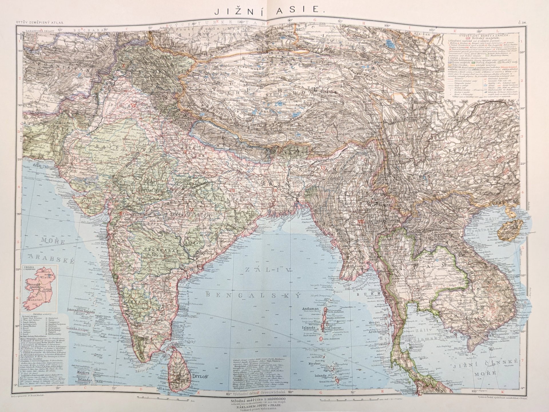
This was actually the question that triggered the whole study. Otto’s Geographical Atlas was an extremely ambitious project. It was the first major world atlas produced entirely in Czech, and its editors clearly cared about geographical nomenclature. In Central Europe in particular, they made considerable efforts to use Czech or other Slavic place names. But when I looked at the maps of British India, I noticed something quite different. The general geographical terminology was Czech, but many city names remained in English or in forms mediated through English cartography.
I initially considered several possible explanations. Perhaps this reflected a different approach by successive editors, perhaps Czech names were considered important mainly in Central Europe, or perhaps there was even a certain geopolitical openness towards Britain and the Western powers after the establishment of Czechoslovakia. The strongest explanation, however, turned out to be much more practical. The atlas took more than twenty years to complete. Its preparation was interrupted by the First World War, political borders changed dramatically, several maps had to be revised, and the editors themselves admitted that for many parts of Asia and Africa, they depended heavily on English and German sources.
So what I see here is a kind of tension between national ambition and international dependency. Czechoslovakia was building its own scientific and cultural infrastructure, and Czech geography was trying to present the world in its own language. But it still depended on knowledge systems created elsewhere. That is why I describe this process as a kind of “uneven vernacularisation”: the world was being translated into Czech, but not everywhere with the same intensity or success.
4) Looking at the broader relationship between national cartographic traditions and imperial networks, how did British colonial knowledge infrastructures dominate the international circulation of geographical data, and to what extent were European cartographers outside the British Empire able to challenge or bypass those frameworks when mapping India?
I think the key point is that mapping India required access to information, much of which was produced by British colonial institutions. Surveys, administrative reports, gazetteers, transport maps, linguistic surveys, and statistical publications created a huge geographical knowledge infrastructure. So, if a Czech, German, French, or other European cartographer wanted to produce a detailed map of India, they often relied, directly or indirectly, on material that had already passed through British institutions. This meant that colonial classifications, spellings, territorial divisions, and sometimes even particular ways of conceptualising the territory travelled together with the geographical data.
Cartographers outside the British Empire certainly had some freedom. They could translate terminology, select different information, change visual emphasis, or use different nomenclature. So they were not simply mechanically copying British maps. But completely bypassing the colonial information infrastructure was much more difficult. If the most detailed and accessible geographical information came from British surveys, then even a national atlas produced in Prague was working within an informational environment strongly shaped by the Empire.
This is something I find particularly interesting: political independence or cultural independence does not automatically mean epistemic independence. A country can produce its own national atlas and still rely heavily on knowledge created within another political system. At the same time, I would be careful not to describe this circulation as completely one-directional. Recent research also shows that colonial knowledge itself was produced through complex networks involving European scholars, colonial administrators, and local Indian intermediaries. So even the supposedly “British” geographical knowledge of India was more hybrid than it may appear at first sight.
5) How does the image of India emerge from these cartographic works, and in your experience, have you encountered recurring stereotypes or geopolitical biases in how European atlases visually and spatially framed the territory?
I would probably be slightly cautious with the word “stereotype”, at least at this stage of my research, because I would like to compare a larger number of European atlases before making strong generalisations. What I can already see, however, are recurring spatial and geopolitical biases. India often appears primarily as a territory to be organised and classified. Administrative boundaries, major cities, railways, rivers, ports, and other elements important to colonial governance or economic activity can be highly prominent. That creates a particular image of India. It may appear as a coherent administrative space that can be divided, measured, connected, and governed, while cultural complexity at the local level becomes much less visible.
Naming practices reinforce this effect. When Indian settlements appear through English-mediated names, the European reader encounters the subcontinent through a linguistic layer created by colonial administration and cartography. But I think one has to distinguish between different kinds of bias. Some are clearly political, while others come from practical cartographic conventions. A small-scale atlas map has to simplify reality. The important research question is therefore not whether maps simplify – all maps do – but why certain features are consistently preserved in that simplification, and others disappear. This is also why comparative work is so useful. When we compare how the same territory is represented in British, German, Czech, French, or other atlases, differences in selection and naming can tell us a great deal about the geographical imagination behind each cartographic tradition.
6) What connections do you see between your work and ESIND, especially in terms of how integrating historical cartography with textual and visual analysis deepens our understanding of European cultural and geopolitical imaginaries?
For me, the connection with ESIND is very natural because ESIND is interested not only in India itself, but also in the different ways India has been imagined, described, represented, and interpreted in Europe. Historical cartography adds another type of source to this discussion. We often study representations through literature, travel writing, newspapers, schoolbooks, or political texts. Maps can sometimes appear more objective because they use coordinates, boundaries, symbols, and measurements. But they are also cultural artefacts.
By combining cartographic analysis with textual and visual analysis, we can ask questions that would otherwise be difficult to see. Why is one region shown in great detail while another is almost empty? Why are certain cities highlighted? Why is one geographical name translated while another remains in English? Why are political boundaries visually stronger than cultural or linguistic regions? These details allow us to reconstruct what I would call a geographical imagination of India.
I also think this approach fits very well with the comparative nature of ESIND. If researchers working with Czech, German, Italian, French, Polish, Hungarian, or other sources begin comparing maps and atlases, we may discover both common European patterns and important national differences. So I see historical cartography as one additional layer in the wider ESIND project. It allows us to study not only what Europeans said about India, but also how they literally positioned India on the map.
7) Can you suggest a reading or a movie that could allow the reader to approach this topic for the first time, or perhaps a specific historical atlas or map that captures the politics of mapping India?
For someone approaching this subject for the first time, I would recommend Matthew Edney’s Mapping an Empire: The Geographical Construction of British India, 1765–1843. It is a very important book because it shows clearly that surveying and mapping were not simply technical activities. They were deeply connected to the process by which British colonial authorities sought to understand, organise, and govern India. What I like about the book is that it changes the way you look at a map. After reading it, you begin to ask not only whether a historical map is accurate, but who produced the knowledge behind it, for what purpose, and through which institutions.
If I were to choose one historical cartographic work instead, I would point to James Rennell’s A Bengal Atlas from the late eighteenth century. It is slightly earlier than the period I usually work on, but it is a fascinating starting point because it captures an early stage in the development of systematic British colonial mapping in South Asia. Even its original title – referring to maps of the “theatre of war and commerce” – tells us a great deal about the relationship between geographical knowledge, military interests, and economic power.
And perhaps, after looking at Rennell’s maps, I would suggest opening a later nineteenth- or early twentieth-century European world atlas and comparing the two. That simple comparison already raises many of the questions that interest me: What has changed? What has remained? And whose geographical language are we actually looking at?
Emil Drápela was interviewed by Giuseppe Resta in October 2026